
The national GNSS reference stations do not only provide GNSS correction data, but also establish an accurate network in order to realizdtech-ltm-projection-paramee the national reference system called LURES / LUREF (Luxembourg Reference System / Frame). The station’s coordinates are managed in the European reference system, the ETRS89 (ETRF2000 @ 2020.82) and the international reference system, the ITRS. By doing so, the SPSLux network provides a linkage between the national, European and international coordinate reference system.
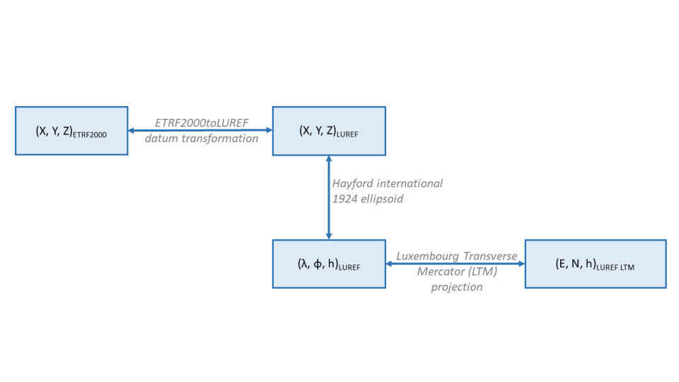
The broadcasted RTCM messages do not supply information about the national reference system. Howeever, they do include ETRS89 reference station coordinates. Therefore, if national coordinates are required, a datum transformation from the ETRS89 to LURES (ETRF2000toLUREF), as well as the LTM (Luxembourg Transverse Mercator) projection has to be implemented within the user’s rover in order to compute coordinates in the national coordinate reference system. The ETRF2000toLUREF datum transformation is regularly evaluated and published by the Luxemburgish cadastre and mapping authority. Up-to-date parameters for the datum transition and the LTM projection can be downloaded below. If no transformations are applied within the user’s rover, coordinates will be obtained in ETRF2000.
Some applications may require WGS84 coordinates. Contrary to the ETRS89 reference system, the WGS84 is not stable over time but is tied to the tectonic plate shifts. As of April 2023, positional difference between both systems is about half a meter, increasing about 2,5cm a year. An official WGS84toLUREF transformation does not exist. The ETRF2000toLUREF transformation can be used for approximate WGS84 positions leading to accuracy of about half a meter.
Please note that no official geoid model of Luxembourg is available. The offset between the GNSS ellipsoidal height and the physical national official NG-95 height system is modeled as part of 3D transformation within the geodetic datum transformation ETRF2000toLUREF. As a result, using SPSLux services in combination with the the above mentioned transformation leads to national LUREF coordinates with horizontal accuracies of 2-3cm and vertical NG-95 accuracies of 5-15cm, good GNSS conditions and measurement conducted in a professional manner assumed.